NWS: Severe Storms Are Possible in Indiana on Thursday

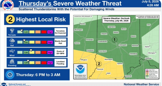
STATEWIDE–There are chances for severe storms in Indiana over the next few days, starting with Thursday.
“As we get into Thursday and moving through the end of the week, we do have higher chances for showers and thunderstorms. It looks like chances really start to increase late tomorrow, so late Thursday, tomorrow night, and it continues into Friday and then through Saturday. And some additional chances do continue into Sunday, but it looks like we should start to dry out late weekend, especially into early next week,” said Greg Melo, meteorologist with the National Weather Service in Indianapolis.
Melo believes the storms will likely move in during the late afternoon hours on Thursday and last into the evening hours.
“We have the potential for some isolated damage to wind gusts. That is the primary threat in terms of severe hazards, but we do also have a flooding threat as well. It’s late tomorrow and really continuing through Saturday,” said Melo.
Rain amounts are a little hard to say at this point, says Melo.
“We get locally heavier rainfall, but generally somewhere around that one to three inch rainfall amounts. Wouldn’t be shocked if some locally higher amounts in some spots, but it’s hard this time of year with thunderstorms. Some areas, very localized areas, can see higher rainfall amounts,” said Melo.
It’s also supposed to warm back up in the coming days. Melo expects high temperatures to be close to 90 Thursday and Friday with similar circumstances at times next week too.