Tornado Outbreak Risk Expands Across Indiana
STATEWIDE –The severe‑weather threat is increasing across Indiana, and forecasters say damaging winds, large hail and tornadoes are all on the table. They add that tonight’s setup favors supercell storms, the kind that can produce outbreaks.
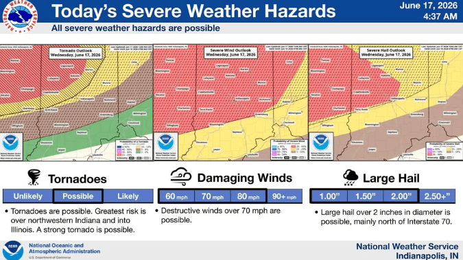
National Weather Service forecaster Crystal Pettet says the risk area has expanded with the latest forecast update.
“What we’re looking at right now is the first round of storms coming in around 1 to 2 o’clock,” Pettet said. “They’re in Illinois right now and they’ll be making their way here, and they’ll have damaging winds associated with them.”
Pettet says the greatest tornado threat comes later tonight as a second round of storms moves through.
“Around 9, 10 p.m., that’s really when that tornado risk increases because we’ll have a front in the area,” Pettet said. “There’s a lot of instability, there’s a lot of shear available, so all of those ingredients coming together means we’ve got significant tornado potential here.”
Pettet says the latest updates show the environment is favorable for a widespread severe weather event.
“The parameters that we typically look at for a tornado outbreak are in place today,” Pettet said. “All of those things are on the table.”
Forecasters say storms could develop into supercells, which can produce multiple types of severe weather.
“They’ve got enough to create large hail, to create tornadoes, to bring in damaging wind,” Pettet said.
Because the greatest tornado threat could happen after dark, Pettet says people need a reliable way to receive warnings overnight.
“The most important thing when we’re talking about things arriving at night and after dark is making sure that you have a way to get those warnings,” Pettet said.
Pettet says outdoor warning sirens are not designed to alert people inside their homes.
“Outdoor sirens are intended to be heard outdoors,” Pettet said. “You need a way to be able to get the information in your house. You need something that’s going to wake you up.”
She recommends using a NOAA Weather Radio and making sure emergency alerts are turned on for cellphones.
“It’s too early to know precisely what we’re going to wind up getting tonight in terms of the size of the tornadoes or tracks or anything like that,” Pettet said.
If a tornado warning is issued, Pettet says people should get to the safest part of their home.
“Get in as far as you can away from outdoor walls and windows, and then get to the lowest floor possible,” Pettet said.


