Storms Could Bring Damaging Winds Across Indiana

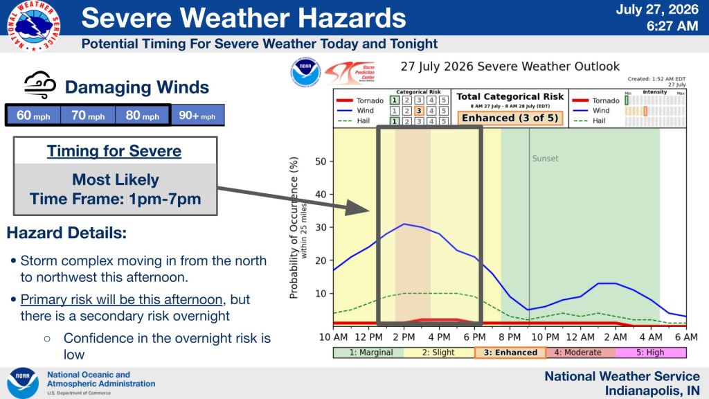
STATEWIDE — Indiana could see strong to severe thunderstorms Monday afternoon, with the greatest threat between 2 p.m. and 7 p.m., according to the National Weather Service.
Forecaster Aaron Updike said another round of storms is possible overnight, but the afternoon is expected to bring the highest risk.
“Around the 2 p.m. to 7 p.m. timeframe across central Indiana, we do have an additional risk of more storms firing up overnight, but that’s going to be more of a secondary risk,” Updike said. “The main risk is going to be those damaging wind gusts of 60 to upwards of 80 mph. Most of it would be more in that 60 mph range, but we can’t rule out some higher wind gusts depending on how organized the system is as it comes through.”
While damaging winds are the primary concern, forecasters are also monitoring conditions that could support severe weather.
Updike said three key ingredients must come together for strong thunderstorms to develop.
“We need moisture. We need some kind of wind difference throughout the atmosphere, and we need something that’s going to force it,” he said. “Even when we get these really hot, humid days, it doesn’t mean we’re always going to get severe weather, but we do have those stronger winds aloft with these patterns.”
Forecast confidence often improves only hours before storms develop.
“There’s a lot of variability to it, and a lot of times confidence doesn’t really increase until the day of,” Updike said. “We’ve been able to watch this area over northern Wisconsin and the northern Great Lakes region.”
A weak cold front is expected to move through central Indiana late Monday night into Tuesday morning, bringing a break from the hottest weather.
“We’re expecting a pretty weak cold front to pass through late tonight into tomorrow morning,” Updike said. “It says cold front, but we’re still looking at highs tomorrow in the mid-80s. It’ll feel a little bit cooler, but more toward normal for late July and early August.”