NWS Provides Update on Indiana's Severe Weather Chances...
NWS Provides Update on Indiana’s Severe Weather Chances for Wednesday Night - Page 2
- Northwest Indiana faces a 'moderate risk' of widespread, dangerous storms including tornadoes
- Central Indiana under 'enhanced risk' with storms possible overnight, when weather info is crucial
- Straight-line winds can cover large areas, as dangerous as tornadoes, so residents must stay alert

STATEWIDE-The National Weather Service Office in Indianapolis gave an update on Wednesday’s severe weather chances in a Tuesday afternoon briefing.
Most of northwest Indiana is under a “moderate risk” for severe weather (level four out of five on the severity scale). A “moderate risk” indicates a high likelihood of widespread, long-lived, and potentially dangerous severe storms, including strong tornadoes, large hail, and damaging winds.
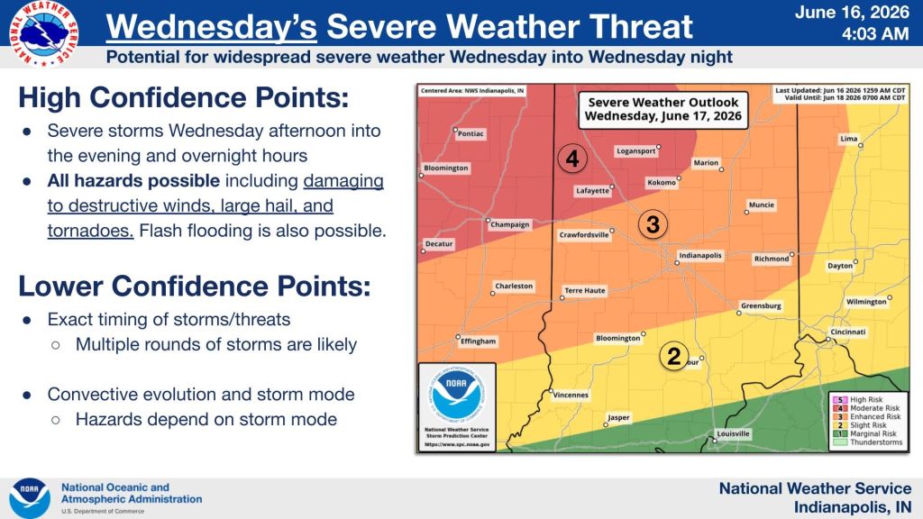
“You can see the level four is in the northwest parts of the state, including Lafayette and Attica and Delphi, and then we still have a large area of enhanced all across central Indiana, all across the I-70 corridor, much of Interstate 69 north of Bloomington, and including the Indianapolis metro area. So, and then lesser chances across far southern Indiana, where there’s just a slight risk in these locations, including Bloomington, Vincennes, Seymour, Columbus, and Bedford. More likely the storm mode at those locations would be a straight line wind event,” said Jason Puma, meteorologist with the National Weather Service in Indianapolis. He was in charge of the briefing.
He also reiterated that some of those storms could be supercells and tornado producers. They project that the worst of the storms are possible between 7 pm Wednesday and 2 am on Thursday.
“After the time some folks have gone to bed, we want to remind folks to have multiple ways to receive weather information. That includes weather radio, that includes cell phones, that includes media, all sorts of ways to receive severe weather information. Please continue to have that stuff ready and message that to folks to have those things ready,” said Puma.
Even though tornadoes are possible, Puma says you can’t sleep on straight line wind damage.
“Sometimes straight line winds can occur over a much larger area than a tornado does, where a tornado can be just kind of precise in one area. All are hazards, and all are things we need to be aware of. So again, in this sort of thing, there’s a good messaging to have as this could be occurring during the nighttime hours,” said Puma.
An “enhanced risk” means there is a higher-than-normal chance of widespread severe thunderstorms capable of producing damaging winds, large hail, or tornadoes. Much of central Indiana is under an “enhanced risk” on Wednesday night. A “slight risk” of severe weather means that organized severe storms are possible, with a higher chance of impactful weather than a marginal risk, but widespread severe conditions are not expected.


