Severe Weather Threats Return Starting Tuesday
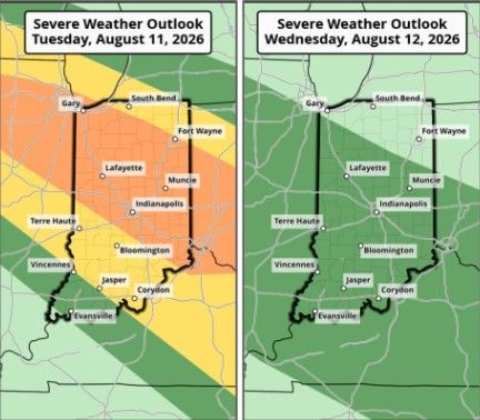
INDIANAPOLIS — The National Weather Service is advising Hoosiers to be “weather aware” this week.
Scattered thunderstorms are expected to develop late Monday evening, with more storms likely Tuesday afternoon. NWS senior meteorologist Jason Puma said they’re seeing a “favorable setup for severe weather on Tuesday.”
“Some of those storms could be strong to severe because we have a very humid air mass in place,” said Puma.
Tuesday’s system will be the start of an active weather week. There’s a chance of rain or thunderstorms just about every day this week with an enhanced risk of severe weather mainly for central and northern Indiana.
“With how warm and humid it’s going to be, all of these storms when they occur could produce some very heavy rain and some of that could result in flash flooding,” Puma said.
Starting on Tuesday, damaging winds and heavy rain are the primary threats, leading to possible flooding. Puma isn’t ruling out isolated tornadoes and large hail either, which are possible in the northern part of the state.
“Be aware of severe weather storm watches and warnings,” Puma added. “Should a warning be issued for your area, that’s the time to take action.”