NWS: Watch Out for Rain in Indiana on Friday
Source: NWS Indianapolis
STATEWIDE–Nearly half of Indiana’s 92 counties are under burn bans because of the dry weather. There could be some additional rain soon.
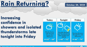
“We’re expecting some showers and even some thunderstorms to develop late tonight across eastern Illinois and northern Indiana and then move into areas north of I-70 by Friday morning,” said Aaron Updike, meteorologist with the National Weather Service in Indianapolis.
Updike doesn’t expect anything more than a quarter of an inch of rain to fall in most areas. If there are thunderstorms, Updike doesn’t expect them to last long.
“The frontal passage should be Friday during the day, so as we get into Friday night we’re not looking at any more rainfall beyond that,” said Updike.
Updike does believe temperatures will hover around the 60s throughout the weekend before warming up next week.
“Right now, we’re looking at low 70s for Monday and then upper 70s for Tuesday and Wednesday, which would be approaching record high temperatures,” said Updike.
He does think a cold front could move in by Halloween, but there is uncertainty.
“We’re confident in the temperatures being higher than normal before then, but we’ll just have to wait and see what happens,” said Updike.
When counties are under burn bans, people in those counties are urged not to burn anything outside because there is an elevated risk for fire in those areas.
You can hear the full interview with Updike below.