NWS: Rain and Hot Weather On Its Way to Indiana
- Rain and strong storms possible Wednesday night through Thursday.
- Severe weather threat mainly in southern Indiana, but could impact I-70 corridor.
- Dangerous heat and humidity expected this weekend, with heat indices up to 105°F.
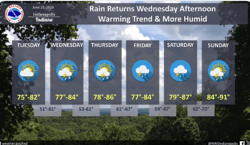
STATEWIDE–Rain and strong storms are possible in Indiana starting Wednesday night into Thursday.
“And as we move later into this week, especially Thursday night into Friday, we’ll be watching the potential for heavy rain and then also can out rule out a few strong to severe storms, mainly just damaging wind threat. But we’ll continue to watch that,” said Greg Melo, meteorologist with the National Weather Service in Indianapolis.
Melo says there’s a lot of uncertainty in terms of the risk for severe weather.
“But we do think we’ll see some heavy rainfall late this week. So we’ll be watching. And then as we get into the weekend, we do it does look like our rain chances do start to decrease, but we’re going to start to get much hotter and more humid as well,” said Melo.
If there is severe weather later in the week, Melo thinks the best chances for that are in southern Indiana, but he can’t rule out the possibility that it could hit closer to the I-70 corridor as well.
He also emphasized the importance of watching out for hotter weather with greater humidity this weekend.
“We will be watching the potential to have to issue heat advisories. It looks like we could have heat indices approaching, you know, 100, possibly even up to 105 for portions of the area. So just to remind everyone, if we do issue heat advisories, just remember to take breaks, stay hydrated outside if you are outdoors during the afternoon hours,” said Melo.
Indiana has also seen 49 tornadoes in June and 68 total for the year so far. The all-time record was set in 2011 with 72. Melo says it won’t take much longer for Indiana to surpass that total.
“But the past three or four years, we have been in a more active pattern. And what’s caused it this year is that normally the jet stream is much further north up into Canada, but it’s been further south. It’s kind of sticking around near the Great Lakes region. And so that’s been keeping our active pattern in place across Indiana. And so that’s why we’ve seen so many tornadoes here in June. And as you know, in the last two weeks or so, we’ve been quite busy here with nonstop repeated rounds of thunderstorms, severe thunderstorms. So hopefully we’re going to see a break here soon. We’re hoping for that, but we shall see,” said Melo.