NWS: Rain and Warmer Temperatures Supposed to Move into Indiana Soon

STATEWIDE–Some scattered rain showers are supposed to return to Indiana this week and it gets warmer.
Isolated to scattered storm chances return to Indiana starting as early as Wednesday afternoon and those will be mainly focused in the southern portions of the state.
“But as we get into Thursday and really continuing through the end of the week is when our chances really start to increase across much of the state. And we have those chances, widespread chances, Thursday night, late Thursday, continuing through Friday, and then as we get into Saturday we still have some elevated rain chances before those precip chances do start to drop off Sunday into early next week,” said Greg Melo, meteorologist at the National Weather Service in Indianapolis.
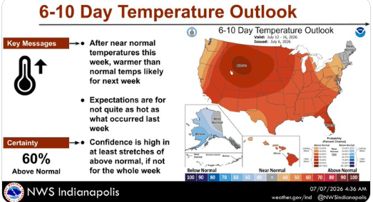
Melo says temperatures will continue to gradually warm up as well.
“I think those temperatures really start to increase as we get into the late weekend into early next week. With the rain and clouds that we are expecting, temperatures shouldn’t be too bad through about Saturday. But as we get into Sunday and into next week, looks like our highs do get back into the upper 80s, maybe even approaching 90 for portions of the state,” said Melo.
He’s most concerned about heavy rainfall.
“This time of year, we always are concerned about flooding just due to the fact that our storms can produce torrential rainfall rates. And so we are seeing that potential along with the threat from multiple rounds of storms. So that is our main concern at this time, late Thursday through Saturday,” said Melo.
There could also be damaging winds, but Melo says the severe storm threat is not super high at this point, but they’ll know more about that in the coming days.