NWS: Rain, Fog, and Severe Weather Ahead
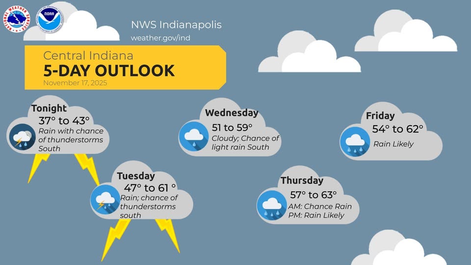
INDIANAPOLIS — Rain is expected to continue across Indiana through Tuesday evening before winding down around midnight, according to forecaster Andrew White of the National Weather Service in Indianapolis.
“We’re expecting the rain through the evening, starting to wrap up toward the midnight timeframe,” White said. “But then as we look past midnight, there will be potential for some fog toward Wednesday morning, and that fog obviously can create some headaches for people if you’re driving around.”
White said the fog should “probably wrap up by 9 o’clock.”
Thunderstorms may develop within Tuesday’s showers. “Thunderstorms [are] possible, I guess, within these showers,” he said, adding that the main hazard over the next 24 hours is hail. “The big thing today is going to be small hail across Georgia — if you get to the Evansville area, [there’s a] higher threat for being a little bit larger.”
He said there is also “a very low wind threat for tornadoes right along the Ohio River this evening.”
Asked about the size of that tornado threat, White said, “It’s just a ‘get for it.’ It’s not gonna be long lasting,” and added that the risk is expected to stay south of central Indiana. “We’re really expecting that to remain more and far into Kentucky.”
Temperatures remain variable this week. “Temperatures have been up and down. Yesterday it was much chillier than the start of today,” he said.
White said he is “not really expecting” any snow over the next week and that conditions should be “near normal this time of year.”
Rain chances return Thursday and Friday. “We’re expecting it to stay right across the state,” White said. He added that rainfall totals will “probably be close to the Ohio River again,” and that “a little bit of thunder” is possible both Thursday and Friday.
A detailed Thanksgiving forecast is not yet certain. “We’re too far away from that… to say anything with confidence,” White said, though an active pattern with some rain remains possible.
White said daytime highs through the rest of the week should be in “the mid-50s” with nighttime lows in “the mid-30s [to] low 40s.


