NWS: Stormy Weather Possible This Week in Indiana
NWS: Stormy Weather Possible This Week in Indiana, Followed by Heat
STATEWIDE–Rain is possible throughout Indiana this week, but then temperatures heat up.
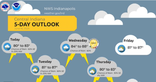
“Generally most of the area is going to stay dry Tuesday and Tuesday night, but then we’ve got those storm chances Wednesday into Wednesday night. The main threat to watch out for damaging winds and large hail. For some of those areas that saw heavy rain this past weekend, flooding will be a concern,” said Andrew White, meteorologist with the National Weather Service in Indianapolis.
White says Evansville and surrounding areas had some flash flooding. The same can be said for the south of side of Kokomo. He also wants you to be aware of how hot it’s about to get.
“We’re going to see high temperatures across most of the state near 90 and into the low 90s for Sunday and Monday. When you combine that with dew points in the mid-70s, that’s going to be bring heat index values around 100 to 105. These are definitely going to be the hottest heat index values we’ve seen so far,” said White.
White says it’s best to start planning and thinking about how you’ll deal with the heat too.
There are daily chances for at least isolated thunderstorms with a slight chance of severe weather on Wednesday.


