NWS: Indiana Rain to Snow Wednesday Night
STATEWIDE — A midweek weather system is expected to bring a chilly rain changing to light snow across central Indiana late Wednesday into Thursday morning, according to Marcus Bailey of WISH-TV.
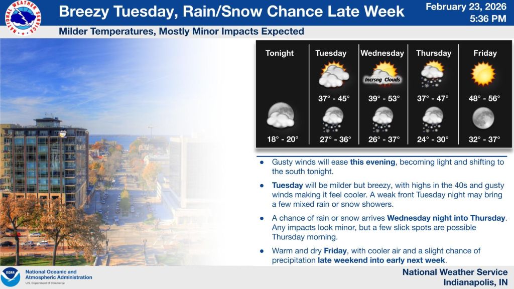
Bailey said the region felt the effects of a powerful system earlier this week, which brought gusty winds and light flurries Monday as it pulled down cold air from Canada.
The next system arrives Wednesday night. It is not particularly moisture-heavy, but timing will be important as temperatures drop overnight.
Precipitation is expected to begin as a chilly rain Wednesday evening before transitioning to snow as colder air moves in. Snow showers are likely to develop overnight and linger into early Thursday morning.
While significant accumulation is not expected, light snow could create slick spots for the Thursday morning commute. People may want to allow extra travel time, especially before sunrise.
“This is more of a late-night event Wednesday carrying over into Thursday,” Bailey said. “It’s not a huge player in terms of moisture, but it’s all about the timing.”
Conditions are expected to improve later Thursday as the system pushes east.
As February turns to March, daylight hours are increasing and average temperatures are gradually rising. Typical highs in early March are in the mid-40s, though swings into the 30s and 40s remain common this time of year.
Snowfall in March is not unusual in Indiana, but late-season systems are typically less intense and shorter-lived than those seen in midwinter.
Looking ahead, the 8- to 14-day outlook points toward near-average temperatures. With early March averages in the mid-40s, that could mean occasional days reaching into the 50s.
For now, Bailey says people should monitor the forecast and be prepared for light snow and possible slick travel early Thursday before conditions improve later in the day.