NWS: Temperatures Below Freezing and Snow Possible
NWS: Temperatures Below Freezing and Snow Possible Later this Week
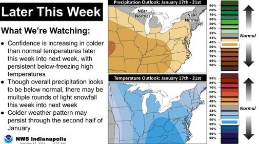
STATEWIDE–Snow could arrive in Indiana this week.
“There’s no really strong target for one area vs another just because of the nature of the setup. The setup looks like we’re going to be in a northwest flow of cold, polar air coming down along with a low pressure system near the Great Lakes. That’s favorable for ongoing snow showers from time-to-time,” said Jason Puma, a meteorologist with the National Weather Service in Indianapolis.
Puma says a cooldown will happen in the later part of the week along with chances for snow going from Wednesday through Saturday.
“Wednesday is going to be our transition day where we have a system moving through bringing us chances for rain at about 60%. Thursday looks to be a dry day and then there’s a 50% chance for snow on Friday. Then we have about a 30% chance of snow for Saturday,” said Puma.
Temperatures are expected to drop into the 20s by Saturday.
“Bundle up and practice your winter weather preparedness techniques. Do whatever you have to do stay warm,” said Puma.
He says exact snowfall totals will be determined as they get closer to Wednesday.


