NWS: Enhanced Risk of Severe Thunderstorms
STATEWIDE — Indiana is preparing for a “rollercoaster ride.” That’s the message from Matt Eckhoff, a meteorologist with the National Weather Service in Indianapolis.
While Sunday afternoon remains warm with highs in the 70s, powerful south winds are already gusting up to 55 miles per hour. Eckhoff notes these gusts could happen anytime during the afternoon and are not actually associated with any thunderstorms.
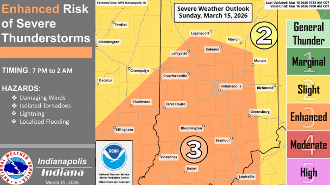
The real danger arrives this evening as a line of severe storms pushes in from Illinois. Because the storms are expected to move through between 8 p.m. and Monday morning, the forecast poses a high risk for those already in bed.
“The key takeaway here is you want to have a way to get those warnings to notify you even if you’re asleep,” Eckhoff says. “You don’t want a tornado threatening you and you sleep through it.”
Then, the spring-like warmth will vanish almost instantly. Temperatures are expected to drop to 40 degrees by Monday morning, bottoming out in the upper 20s.
“Those snow showers tomorrow could be heavy at times,” Eckhoff says. “Brief, but heavy. That could lead to some slick spots and some icy spots” during the Monday morning commute.”
The bitter cold is expected to bottom out Tuesday morning with lows in the teens with single digit wind chills near zero at times. However, the temperatures won’t stay down for long; after the midweek deep freeze, forecasters expect the state to bounce back with highs “potentially in the 60s to near 70 by Friday.”