NWS: Severe Storms Possible for Indiana on Thursday
STATEWIDE–Severe weather is possible on Thursday across Indiana.
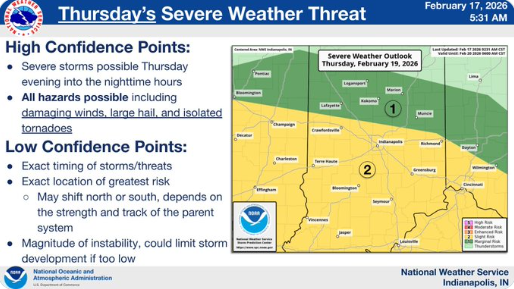
Much of central and all of southern Indiana is under a slight risk for severe weather (level 2 out of 5 with 5 being the highest risk for severe storms). In this category, you could face significant weather conditions, such as hail larger than one inch, damaging winds over 60 mph, and even the potential for tornadoes. This risk level demands that residents stay informed and prepared, as the likelihood of severe weather is considerably higher than in the marginal risk category.
“Our main concern is the timeframe of Thursday afternoon into Thursday evening. The main concern we have is damaging winds, but there is also the possibility that we could see tornadoes across the state,” said Andrew White, meteorologist with the National Weather Service in Indianapolis.
White says the threat is greater the further south you go.
“We’re concerned about Indianapolis down to the Ohio River. Closer to the Ohio River is where that threat is maximized,” said White.
There could be some small hail along with the possibillity for damaging winds. High temperatures across Indiana will get into the 60s this week, but after Thursday, White expects temperatures to cool down.
“The cool down starts Friday with temperatures dropping into the 50s. That starts a cooling trend that heads into the weekend and then we’ll have the return of below normal temperatures early next week,” said White.