Storm Could Drop 2–3 Inches Across Indiana by Tuesday
INDIANAPOLIS — A winter storm is set to hit Indiana late Monday. Meteorologist Alex McGinnis says it could bring several inches of snow, slick roads, and tricky travel conditions.
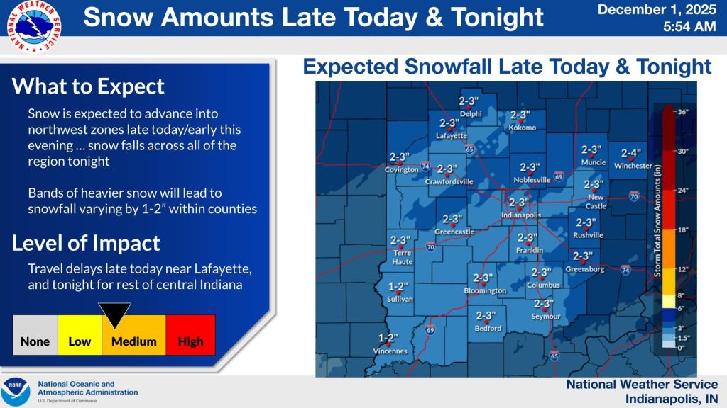
Central Indiana is under a winter weather advisory from 7 p.m. tonight until 7 a.m. Tuesday morning.
Snow is forecast to begin as early as 4 to 5 p.m. in western parts of the state, including Lafayette and Crawfordsville, before spreading eastward through the evening. McGinnis said the Indianapolis metro area will likely remain dry through most of the evening rush hour, with snow arriving closer to its end and continuing overnight.
“Some areas may not be seeing much at any given moment, but a county or two away, there could be a solid band of snow,” McGinnis said. “It’ll be on and off, but by pre-dawn Tuesday, most places will have 2 to 3 inches on the ground.”
Higher totals near 4 inches are possible in isolated spots, while areas south of Terre Haute toward Vincennes are expected to receive slightly less.
The timing of the snowfall is expected to affect travel tonight and again early Tuesday as crews work to clear the roads. Even after the snow tapers off early Tuesday morning, a fresh coating may remain on untreated surfaces.
The warning comes after a weekend marked by numerous accidents across the state, including a multi-vehicle pileup near Terre Haute. Monday began with temperatures near 20 degrees in Indianapolis, leaving untreated roads frozen and producing patches of black ice.
“Anything not treated is frozen solid,” McGinnis said. “Plan for extra time on the roads. Even with the breeze we’ve had the last few days helping to dry surfaces, there will still be icy spots.”
An active but mostly minor winter pattern will continue through the week. Snow showers are possible again late Wednesday into Wednesday night as an Arctic front moves through northern Indiana. Temperatures are expected to fall sharply, with highs only in the teens or 20s on Thursday and lows dropping toward zero or into the teens Thursday night.
Forecasters are also monitoring a system late Friday into Saturday, though confidence remains low and only light precipitation is expected at this time.
While early-season cold and accumulating snow are unusual for central Indiana, McGinnis noted it has happened before. The region saw significant early-season snowfall in 1997 and recorded early December snow showers last year.
“This pattern isn’t common, but it’s not unheard of,” he said. “We’ll stay cold, and we’ll have these small chances for snow every day or two.”