Heat Advisory Remains as 90-Degree Streak Continues
INDIANAPOLIS — Heat and humidity continue across Indiana this afternoon and into Tuesday, with much of the state under a Heat Advisory. Southwestern Indiana remains under an Excessive Heat Warning, where heat index values could reach or slightly top 110 degrees.
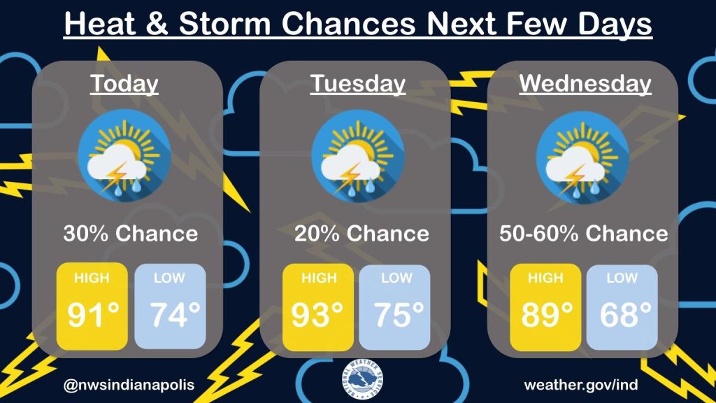
Monday afternoon will bring mostly sunny skies and hot, muggy conditions. Temperatures are expected to reach the low 90s, with heat index values between 100 and 105. There’s also a small chance for a spotty shower or thunderstorm later in the day. Monday marks the sixth straight day of 90-degree temperatures in Indianapolis, bringing the summer total to 19.
Overnight, temperatures will stay warm and humid, with lows around 76.
Tuesday’s forecast looks much the same, with highs climbing into the low to mid-90s. The heat index may once again reach between 100 and 105. A stray afternoon storm is possible.
Another hot day is expected Wednesday before a cold front moves through late in the day, bringing a better chance for showers and storms. Cooler, less humid air will follow the front.
Highs on Thursday are expected to reach near 80, and the weekend is shaping up to be mild and pleasant, with temperatures in the upper 70s to low 80s and overnight lows dipping into the 60s, possibly even the upper 50s by early Saturday.