NWS: Heat and Humidity Continue Across the State
STATEWIDE — Heat was a significant factor across Indiana this past week, and warm conditions are expected to persist.
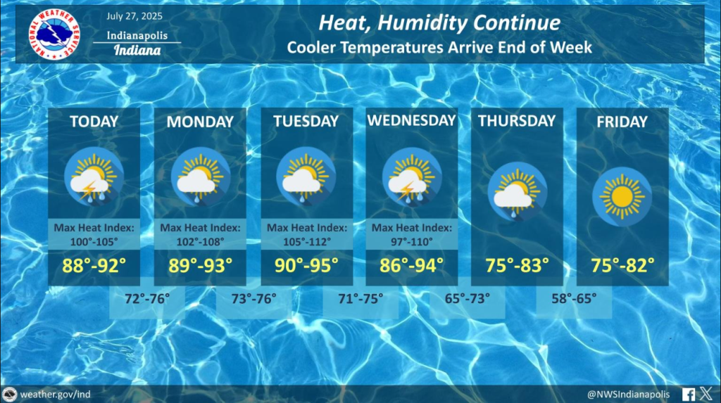
Aaron Updike is a meteorologist with the National Weather Service in Indianapolis, and he shared what to expect for Monday and Tuesday.
“The state of Indiana will get temperatures in the low 90s, as well as heat index values again exceeding above 100 degrees,” Updike says.
Updike says Tuesday is expected to be the hottest day.
“We may see high temperatures possibly approaching the mid-90s, with heat index values rising above 105 to 110 degrees,” Updike explained.
He advised residents to use air conditioning if available and to drink plenty of water.
“This is especially crucial given that overnight lows across the state are not expected to fall below 75 degrees,” Updike says. “That can lead to heat stress, especially for those who are more sensitive to heat.”
Looking ahead to later in the week, Updike mentioned potential changes.
“The state might see increased chances of thunderstorms, so that increases the uncertainty of how hot it will get,” Updike says. “If we get thunderstorms in an afternoon, it simply limits the atmosphere’s ability to reach temperatures above 90 degrees.”
There is an indication of potential thunderstorms later in the week.
“It’s a little bit too early to tell though how widespread that’s going to be and where that coverage will be located,” Updike says. “We recommend that citizens in central Indiana should stay updated on the latest weather trends as Wednesday and Thursday approach. Thunderstorms this time of year, with high humidity and heat, are very capable of producing a half-inch to an inch of rain within 30 minutes to an hour.”
Updike says the state will experience some relief with a bit of a cool down by the end of the week, heading into the weekend.