NWS: Updates About Sunday’s and Monday’s Winter Storms
Source: X / x
UPDATE: Cody Moore from the National Weather Service in Indianapolis says expect more snow on the ground by Monday morning than Sunday.
“A lot of it is going to come while you’re sleeping, so by the time you wake up, you’ll have much more snow on the ground,” Moore says.
Moore says to still expect around eight to 12 inches of snow, and freezing rain will still be a factor as well.
“Now when you wake up Monday morning, most areas in Indiana will have up to 10 inches of snow already on the ground. The heaviest snow is likely Monday morning, and then heavier snow is likely through the afternoon hours,” Moore says.
It is important to be safe out on the roads.
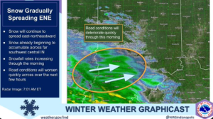
“There is likely going to be traveling across the entire state, especially areas south of Indianapolis. Areas that get any freezing rain or ice is extremely dangerous to drive on, even if roads are treated,” Moore says.
Moore says staying at home is likely the best option during the storm.
STATEWIDE – A winter storm will hit Indiana Sunday. Greg Melo, Meteorologist from the National Weather Service in Indianapolis says there will also be some precipitation issues.
“It looks like the heaviest snowfall will be near the I-70 corridor and locations south of there,” Melo says. “Still thinking eight to 12 inches across that portion of the area. We could maybe see some locally higher amounts across that area as well.”
Melo says sleet and rain will start to mix later in the evening Sunday, leading off into tonight.
“Sleet and freezing rain will probably mix in the late afternoon and into the evening hours, and as we get into the overnight hours, it looks like a good portion of south Central Indiana could turn over to all freezing drizzle,” Melo says.
Southern portions of Indiana may start to see more freezing rain and sleet mixing in, so there may be lesser accumulations across southern Indiana, compared to Central Indiana. Southern Indiana may get around five to 10 inches of snow.
Central Indiana may get heavier snowfall where there could be locally higher amounts of at least eight to 12 inches of snow.
Northern Indiana may get one to two inches of snow.
“As you move more towards Lake Michigan and far northern Indiana, they may not even see an inch of snow,” Melo says.
Melo says temperatures in the twenties this afternoon, and then they’ll cool down in the evening. A lot of snow may happen early Monday.
“Wind chills are likely to drop into the single digits late tonight, so we’ll definitely have some very low wind chills, maybe even near 0 across northern and Central Indiana,” Melo says.


