Source: NWS Indianapolis
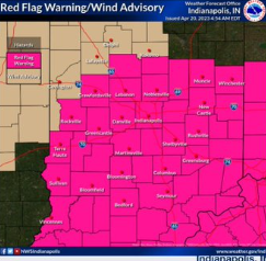
STATEWIDE–Most of the state is under a red flag warning from noon until 8 pm Thursday, according to the National Weather Service. That means conditions are favorable for fires to get out of control quickly with the combination of heat and high wind gusts.
Those gusts could reach 40 mph at times across Indiana.
“You need to be careful with any flammable objects outside and you shouldn’t burn anything outside either. We’re also going to cool down tonight into tomorrow. Temperatures tonight are going to drop into the 50s and run about 20 degrees colder than Thursday,” said Andrew White, meteorologist with the National Weather Service in Indianapolis.
White thinks rain will start arriving to Indiana Thursday night.
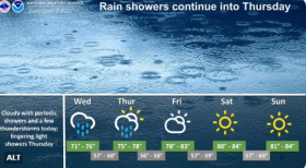
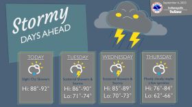
“We’re going to see showers and maybe a couple of rumbles of thunder moving in after 8 pm and moving towards the 10 pm and midnight timeframe. That rain is probably going to continue for much of the night,” said White.
High temperatures start to cool down on Friday.
“We’re probably going to get to the freezing point at some point in the weekend, which is most likely going to be Sunday night. That’s when lows will drop into the 30s,” said White.
White says highs won’t get out of the 60s next week for most cities and towns in Indiana.