NWS: High Wind Warning for Central Indiana Until 7 pm Thursday, Severe Storms Also Possible
STATEWIDE–Heavy rain, high wind gusts, and even some severe weather is possible across Indiana today.
The National Weather Service (NWS) says most of central and portions of northern Indiana are under a marginal risk of severe weather. That means isolated severe storms are possible, with the threat of isolated damaging winds, small hail and maybe a tornado.
The biggest thing the NWS is concerned about today is high wind gusts that could reach 60 mph in some places.


“Just be careful. Stay away from power lines. Secure your outdoor patio furniture and be careful when you drive,” said Mike Koch, meteorologist with the National Weather Service in Indianapolis.
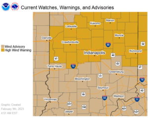
A high wind warning is in effect until 7 pm tonight for areas on I-70 and northward. Everywhere else in Indiana is under a wind advisory until 7.
“An advisory is anytime you have wind gusts from 45 to 57 mph. A warning is for areas that will likely have wind gusts that are greater than 57 mph,” said Koch.
High wind gusts can cause power outages. After 7 pm tonight, the weather starts to get colder.
“Cool weather will stay with us for a couple of days and then it will start to warm back up again next week,” said Koch.