Source: NWS Indianapolis / National Weather Service
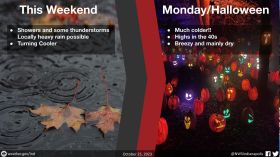
STATEWIDE — It’s an unseasonably cold Sunday with a freeze warning in place, but things will stay the same for most of the week.
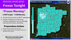
Clouds might roll out of central Indiana later into the afternoon after some possible rainfall, but the biggest thing to watch out for is freezing temperatures. Almost all of Indiana is under a freeze warning that lasts until Monday morning around 8:00 a.m.
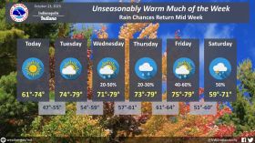
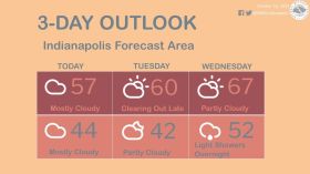
Temperatures will cool down to the low 30s overnight. They won’t get much higher throughout the course of this week.
“Unfortunately during that 7-day forecast we’re not going to get any better than the 40s.” said Brad Harold, Meteorologist with the National Weather Service in Indianapolis.
The soonest it will start to warm up will be towards the end of the week. “High temperatures, probably mid-60s is the best. That will come on Friday,” said Harold.
Until then, he said, it’s a good idea to get out before the temperatures drop and bring in any plants that have already bloomed.