NWS: Indiana Experiencing Cooler Than Normal Temperatures
Source: NWS Indianapolis
STATEWIDE–Average high temperatures are supposed to be below normal across Indiana until at least the end of April, according to the National Weather Service.
In the immediate future, you can expect temperatures to cool down this weekend. An initial cold front moved through Indiana Friday morning.
“A secondary cold front will come in this evening. We’ll see a second batch of showers and maybe a couple of rumbles of thunder, but the pattern doesn’t support severe weather. I think we’re done with any severe weather in central Indiana probably until some point in May,” said Mike Ryan, meteorologist with the National Weather Service in Indianapolis.
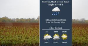
Ryan says there could be some light rain showers Saturday afternoon in certain portions of the state. Low temperatures this weekend will hover around 30 degrees.
“Then as we head into next week we are expecting cooler than normal temperatures as we finish out the month and probably into the first few days in May. The point to take away is that we’re in a spot where high temperatures will be in the 60s. By the time we get into May, it will be in the 70s,” said Ryan.
Ryan says you might see the occasional frost on your lawn or windshield during this time.


