Saturday’s Snow to be Followed by Temperatures Toward Zero
INDIANAPOLIS — The second round of snow to hit Indiana this week will begin falling on Saturday.
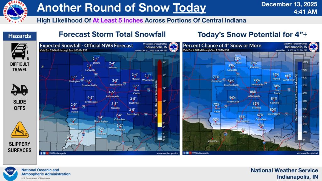
A winter weather advisory had been in place for much of central Indiana through Saturday morning with some areas being upgraded to a winter storm warning. A majority of central Indiana has been placed under a warning from 11 a.m. to 12 a.m. eastern time Sunday.
Meteorologist Greg Melo with the National Weather Service in Indianapolis said they originally thought the snow would start falling sometime in the afternoon, but that changed after looking at the trends early Saturday morning, suggesting that western parts of the state will see snow begin to come down before noon.
“We’ll see the snowfall rates pick up during the afternoon hours and then they should start to taper off towards the evening,” Melo said. “We’re expecting the greatest impacts through the afternoon and then possibly into the evening and overnight as well.”
It’s anticipated that most spots will get 4 to 6 inches of snow. Higher amounts are possible in some isolated areas along the I-70 corridor.
“Roughly from Terre Haute down to Bloomington and north would see the heavier amounts,” said Melo.
After the snow moves out, a cold weather advisory will then be in effect for Sunday from 12 a.m. to 1 p.m. Low temperatures will bottom out near 0 with wind chill values making it feel even colder, around -15 to -25 starting Saturday night.
“We’ll have bitterly cold temperatures with the cold air that moves in and it’ll stick around through Monday morning,” Melo added.
Melo also suggests that folks stay home if they don’t need to travel anywhere over the weekend. If you are required to drive somewhere, be cautious of the conition of the roads.
There is some slightly good news on the back end of this snow storm and arctic chill. Temperatures will begin to warm back up early next week.


