NWS: Storms Could Be Strong in Indiana This Weekend
NWS: Showers and Storms Could Be Strong in Indiana This Weekend
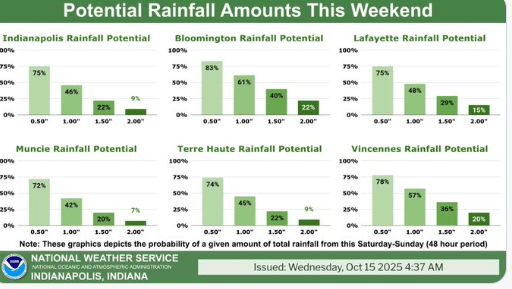
STATEWIDE– A storm system is supposed to produce and rain and thunderstorms for portions of central and southern Indiana this weekend.
“We still have a lot of uncertainty with this. Our guidance has been all over the place with timing on it. We’re expecting the bulk of the rain to move through Saturday night and get into Sunday, but we think the bulk of the rain will be on Saturday,” said Aaron Updike, meteorologist with the National Weather Service in Indianapolis.
Updike says the highest likelihood of rain would be in the southern Wabash valley through the southern Ohio valley. Northern Indiana is also supposed to get some rain.
“That’s where a lot of the uncertainty is at right now. As we get closer to the weekend, we’ll see just how much rain that area of the state could get, but if the system doesn’t push further north, then the northern part of the state would just get some light rain,” said Updike.
The storms could be on the stronger side.
“With trends pushing it into the overnight time frame on Saturday, it does weaken the overall threat of severe thunderstorms, but there is still the chance that we see the storms being strong,” said Updike.
Updike says wind gusts could reach 30 mph at times and the temperatures are supposed to drop into the 60s by Sunday.


