Source: NWS Indianapolis
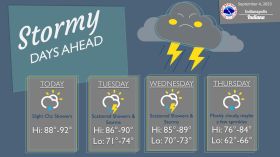
STATEWIDE–There is a chance for severe weather in Indiana on Tuesday.
“It looks like it will be confined to the southern third of the state. Even then, it doesn’t look like the storms will be that widespread,” said Randy Bowers, meteorologist with the National Weather Service in Indianapolis.
Bowers says the main threats to watch out for with that are damaging winds and hail for Tuesday.
Late Monday night, the National Weather Service issued a tornado warning for Bloomington, Ellettsville, and Spencer, but that doesn’t necessarily mean there was a tornado.
“The data said it was good to issue a tornado warning, but our confidence in there being a tornado with that system is pretty low, but we’ll talk with the authorities and continue to investigate in that area to be sure,” said Bowers.
With heavy rain falling in some spots across Indiana in a short amount of time, Bowers urges you to watch out for flooding in some low lying areas.
“There were some estimated amounts on radar, for example, that could have been three inches or more in Monroe County,” said Bowers.
Listen to the full interview with Bowers below.