Heat Lingers, Relief Ahead for Indiana
INDIANAPOLIS — Indiana’s stuck in the heat again today, with a Heat Advisory in effect until 8 p.m.
Some early fog rolled through southern counties after yesterday’s rain, but it’s clearing out fast. After that, it’s all about the heat. Highs this afternoon will climb into the low to mid-90s, and it could feel closer to 105.
What’s making it feel so nasty? You can thank “corn sweat.” That’s the moisture coming off crops and adding even more humidity to the air — especially in farm-heavy states like Indiana. It’s turning up the misery.
Relief is coming. A cold front will sweep in Wednesday night into Thursday, bringing scattered storms and a chance for damaging wind or localized flooding. Most of the state is under a Level 1 severe weather risk — the lowest on the scale, but still worth watching.
By Thursday afternoon, storms move out and cooler air settles in. Highs drop to around 80, and we may not even hit 80 on Friday or Saturday. Dewpoints will also fall, so it’ll finally feel more comfortable.
Lows at night — which have been hanging in the 70s — will sink to the low 60s Thursday night, maybe even the upper 50s in rural spots by Friday night.
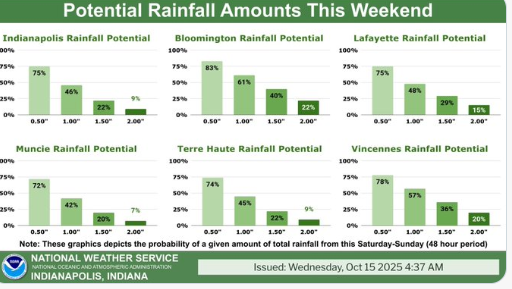
The weekend stays mostly dry with highs in the mid-80s. Storm chances hold off until early next week.