Strong Storms To Arrive By Evening Into Overnight Hours
Source: NWS Indianapolis / other
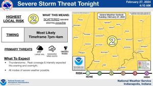
STATEWIDE — Severe weather is still on track to hit Indiana later today in what experts say will be the first large-scale system of strong storms to hit the Hoosier state this severe weather season.
David Beachler with the National Weather Service expects storm activity to start picking up in the late afternoon, but he says the strongest of the storms won’t be here until in the late afternoon into the early evening hours.
“We are still anticipating that some of these storms will produce damaging winds in excess of 55 miles an hour and possibly hail one inch in diameter,” Beachler said. “We do still see the risk of some isolated tornadoes developing.”
NWS Indianapolis and the Storm Prediction Center in Norman, Oklahoma have also now placed all of Indiana from border to border under a “slight risk” for severe weather. That means the chances are likely for strong storms.
Beachler advises that you be prepared for power outages and any storm damage that could happen with these storms.
Looking ahead, Beachler said there will be a brief cool down after the cold front bringing these storms moves through.
“It does look like once the cold front comes through we could see some very light snowfall,” he said. “At best we could see a tenth of an inch of snowfall. Not much accumulation.”
As for the warm temperatures on Monday, he said they measured the highest temperature at 73-degrees which broke the previous record high for Feb. 26 by five degrees. He expects more record highs today ahead of the storm system making its way to Indiana.
—
Listen to the full interview with David Beachler, a meteorologist with NWS Indianapolis: