Source: NWS Indianapolis
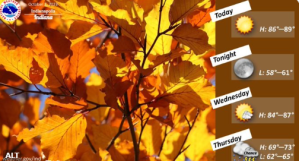
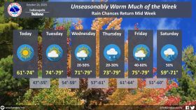
STATEWIDE--High temperatures are supposed to be in the 80s all across Indiana Tuesday and Wednesday, but you can expect a change after that.
“There’s an 85% chance of rain starting Thursday morning. There could even be a rumble of thunder as well. That rain is because a cold front is rapidly approaching the area from the northwest. That cold front is what’s going to bring the big change this week into the weekend,” said Matt Eckhoff, meteorologist with the National Weather Service in Indianapolis.
Eckhoff says all areas of the state need to be ready to experience rain at some point Thursday.
“I think the best chance, though, is from central and southern Indiana at the moment,” said Eckhoff.
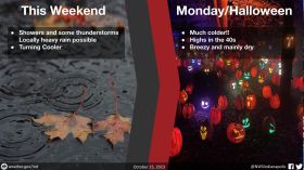
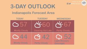
By the weekend, Eckhoff says many places will likely only get high temperatures in the 50s and lows dropping into the 30s.
“There could be a brief warmup here and there, but it finally looks the pattern is about to flip more towards what you would expect for this time of year,” said Eckhoff.
The National Weather Service says temperatures in Indiana typically range between 65°F and 85°F during the day, although they typically are closer to 65.
As nights turn cooler, temperatures can vary from 40°F to 60°F.
You can hear the full interview with Eckhoff below.