Frost, Cooler Weather Ahead for Indiana
INDIANAPOLIS — Central Indiana is in for a noticeable drop in temperatures this week, with highs and lows falling well below what the region has experienced in recent weeks, according to the National Weather Service in Indianapolis.
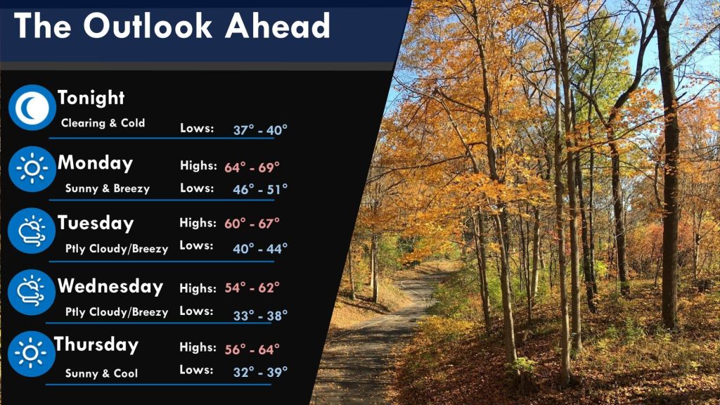
“We’re going to be quite a bit cooler than what we’ve been used to,” said Joe Nield, meteorologist with the NWS. “We’re looking at highs today in the mid-60s, dropping to the mid-50s by Wednesday.”
Temperatures are expected to gradually recover toward 60 degrees by late in the work week and into the weekend, with highs back into the mid to upper 60s by Sunday and Monday.
Overnight lows will also take a dip. While Monday night could still see temperatures in the low 50s, Nield said readings will likely fall into the low 40s by Tuesday night. By Wednesday and Thursday nights, temperatures are expected to drop into the 30s across much of the region, increasing the likelihood of frost.
“People who still have sensitive plants outside should keep an eye on the forecast,” Nield said.
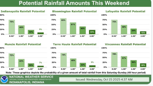
In addition to the temperature changes, the area has also seen some of the most widespread rainfall in several weeks. Some parts of central Indiana received up to 3 inches of rain over the weekend, which could help ease ongoing drought conditions.
There’s a slight chance for additional showers late Monday night into Tuesday, with a 20 to 30 percent chance of precipitation northeast of the Indianapolis metro area Tuesday afternoon and evening. Another chance for light rain could return Thursday night, especially across northern portions of the region.
“This is the coolest stretch we’ve seen so far this season,” Nield said. “It’s a good reminder that fall is definitely here, and winter isn’t far behind.