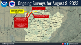
Source: NWS Indianapolis
STATEWIDE–The National Weather Service has confirmed that four tornadoes touched down in Indiana on Sunday.
An EF-2 twister caused damage in Johnson County. It traveled more than five miles between 4:13 and 4:23 p.m. An EF-1 tornado then impacted Daviess and Martin Counties between 4:24 and 4:30 p.m. before another tornado hit southwestern Monroe County between 4:30 and 4:37. The fourth and final tornado caused a home to collapse in southern Martin County, which also reached Dubois County. It was an EF-2. One person died.
“The longest track that we had was the Martin-Dubois County tornado. That had a path of about nine miles. In terms of wind speed, our strongest tornado was the Martin-Dubois one with 120 mph wind gusts. The Johnson County tornado reached 115 mph. The other two were slightly weaker,” said Greg Melo, meteorologist with the National Weather Service in Indianapolis.
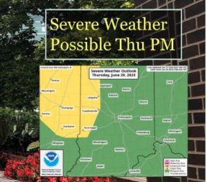
Melo says this might not be the end of severe weather this week either.

“For Wednesday night through next Monday, we’re going to have storms around. There will be clusters of storms. There could be severe weather. We do have a severe weather risk for Thursday,” said Melo.
Melo says it’s too early to see exact details of Thursday’s storm potential, but he urges everyone in Indiana to be on the lookout for damaging winds, hail, and possibly an isolated tornado.