NWS: Thursday’s Storm in Indiana Now Classified as a Derecho; Power Likely to Be Fully Restored Soon
Source: WISH-TV
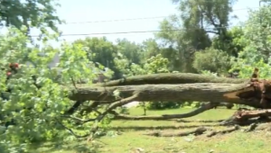
STATEWIDE–Thursday’s storm that occurred in Indiana is being called a derecho by the National Weather Service.
A derecho is a widespread, long-lived, straight-line wind storm that is associated with a fast-moving group of severe thunderstorms. Derechos can cause hurricanic and tornadic level winds, heavy rains, and flash floods.
This particular derecho included a wind damage path that extended more than 240 miles and had wind gusts of at least 58 mph. Forecasters believe the storm Thursday had the force of a tornado and the mass of a hurricane.
“It met the specific criteria for length, duration, and high wind gusts. Usually you get wind gusts over 70 mph. We had several gusts like that in central Indiana. That’s what caused all of the tree damage and the power outages,” said Chad Swain, meteorologist with the National Weather Service in Indianapolis.
Barring anymore severe storms, AES Indiana expects to have all of the power restored to its customers by Monday morning.
“AES Indiana increased its personnel by 50% and brought in additional crews from neighboring utilities in Illinois, Ohio and Tennessee to help with the restoration efforts. At its peak, more than 80,000 customers were impacted by Thursday’s severe storm,” said Kelly Young, public relations director for AES Indiana.
Executives with Duke Energy say they are also making progress.
“We’ve made a lot of progress, but we still have a lot of work ahead of us,” said Anthony Brown, Duke Energy’s Indiana storm director. “The widespread nature of this storm, which affected nearly all of the 28 Indiana districts we serve.
Duke Energy estimates the vast majority of remaining outages in the following regions will be returned to service by midnight Sunday, although most customers affected will receive their power sooner:
-Bedford
-Bloomington
-Clinton
-Greencastle
-Princeton
-Sullivan
-Terre Haute