
Source: NWS Indianapolis
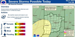
STATEWIDE–Severe weather is possible across Indiana Monday, according to the National Weather Service in Indianapolis.
“Somewhere in the mid-to-late afternoon timeframe would be when the greatest chances for severe thunderstorms would develop. There could be some large hail and damaging winds. We also can’t rule out an isolated tornado,” said Randy Bowers, meteorologist with the National Weather Service in Indianapolis.
Bowers thinks the parts of Indiana likely to experience severe weather would be in the central and southern part of Indiana.

“It’s not looking like a severe weather outbreak of any kind, but it’s definitely something to watch out for,” said Bowers.
The portions that are in southwest Indiana especially, are under a “slight risk” of severe weather. That means that scattered severe storms are possible but typically are short-lived and not widespread.
The rest of the state is under a “marginal risk”. That means isolated severe storms are possible, with the threat of isolated damaging winds, small hail and maybe a tornado.
Once Tuesday rolls around, Bowers says things change.
“We’re not expecting rain once we get to Tuesday. By the middle of the week, temperatures will go back up into the 80s. Things will stay mostly dry during that time. By the time we get into late in the week, there could be some light showers,” said Bowers.


