Source: National Weather Service in Indianapolis / National Weather Service in Indianapolis
STATEWIDE — A round of severe weather is likely to hit Indiana in the next couple days.
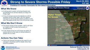
On Friday, the National Weather Service expects a line of storms to mainly impact the western portion of Indiana, but they say the risk for heavy rain and high winds is still there for the rest of the state. They expect the storms to hit late in the evening Friday and stick around into Saturday morning.
“Even outside of any thunderstorms, winds are going to be pretty gusty, 30-40 miles an hour potential,” said Cody Moore, NWS Indianapolis meteorologist. “It’s going to be raining much of Friday night.”


They are also not ruling out possible tornadoes with this system. Finally, flooding from last week’s heavy rain is expected to be made worse by this next line of storms.
“We have a couple of areas (in southern Indiana) in moderate flood stage.,” Moore said. “So we are expecting rivers to rise and there is the localized flooding potential as well.”
The storms are expected to clear out by late Saturday, he says.


