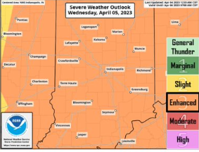
Source: NWS Indianapolis
STATEWIDE-The National Weather Service says all of Indiana is under an “enhanced risk” for severe weather on Wednesday. That is a level three risk out of five with five being for the strongest risk. It means tornadoes, damaging winds, hail, and heavy rain are all possible.
“It may be one round of storms. It may be a couple of rounds of storms. That’s where some of the uncertainty comes at this point. We know in that window from Wednesday morning to Wednesday afternoon could certainly become severe,” said Randy Bowers, meteorologist with the National Weather Service in Indianapolis.
Bowers says there is still some conflicting data on how severe they will be.
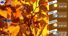
“It doesn’t look like it will be quite as significant of a system as Friday. Thunderstorms that would move in on Wednesday morning don’t look like they’ll be as intense from a tornado standpoint, but there is a lot of instability in the atmosphere so a risk for tornadoes can’t be ruled out,” said Bowers.
Bowers says the biggest threats to watch out for throughout the day Wednesday are tornadoes, damaging winds, and hail.
The storms are expected to move out of the state by Friday.