Source: NWS Indianapolis
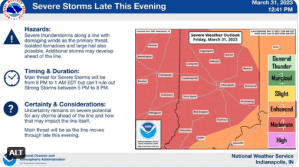
STATEWIDE–The entire state of Indiana is under at least an enhanced risk of severe weather while a large portion is under a moderate risk of severe weather.
A moderate risk for severe weather is significant. Widespread severe weather is likely. Storms can be long-lived and intense. This is when there is a greater chance to see damaging winds and large hail than not in a 25-mile radius.
An enhanced risk for severe weather means numerous severe storms are possible and are more persistent and widespread with a few instances of very intense storms. Under this risk, several spots will likely experience damaging winds and/or large hail.
“The main timeframe we’re concerned about is 8 pm to 1 am Saturday, but then those additional storms ahead of it could start as early as 4 or 5 pm. We’re pretty confident the line will be severe with damaging winds. Some winds could be in excess of 75 mph,” said Andrew White, meteorologist with the National Weather Service in Indianapolis in a Friday afternoon news briefing.
White is most concerned about people in southern Indiana.
“The best chance to get tornadoes in places like Terre Haute to Bloomington and points southwest. That’s the main area we’re concerned for, especially when it comes to tornadoes. There is potential for straight line wind damage and power outages,” said White.
If there is hail, White says it could be “quarter sized hail.”
A wind advisory will be in effect for nearly the entire state for most of the day Saturday.