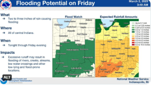
STATEWIDE–Most of Indiana is under a flood watch, according to the National Weather Service. They predict that rain will start moving into the state early Friday morning sometime after midnight and last throughout the day.
“We’re anticipating that anywhere between two and three inches of rain will fall around the Indianapolis metro area and the amounts will likely be heavier further south,” said David Beechler, meteorologist with the National Weather Service in Indianapolis.
There could be flooding in some low-lying areas. Rainfall totals are projected to be lighter in the northern parts of Indiana.
“Up there, there could be light snow mixing in with the rain. Across places like Lafayette, Monticello, or Kokomo, it looks like they will get around an inch to nearly two inches. But here’s the caveat with all that. This system is still developing, so the precise location of who’s going to see the highest rainfall totals could fluctuate,” said Beechler.
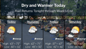
By the time Friday night rolls around, Beechler believes things will have calmed down.
“The downward trend of rain begins in the afternoon. Then by late Friday night we should dry out pretty quickly and conditions also look dry for the weekend,” said Beechler.
Beechler says most places in Indiana will cool down into the 40s on Friday, but then it warms back up again early next week into the 50s and 60s.