
INDIANAPOLIS — Strong winds from Monday’s storms blew over trees and downed some power lines in Central Indiana. While the system has moved on, crews are still surveying damages.
Meteorologist Randy Bowers at the National Weather Service in Indianapolis says that there was possibly a tornado, “One area of interest that we’re looking at – we don’t have anything official yet – but on the southeast side of McCordsville in the northern part of Hancock County it looks like that there was an area of rotation. Some indications on radar that there had been a tornado.”
Bowers said a NWS crew is expected to go out later Tuesday morning to survey the area, but they don’t have reports of significant damage or any injuries.
Strong rains from the storm still leave parts of the state under a flood warning and hazardous weather outlook.
“The rain that we had recently has been enough to where that’s trickled down to the streams and into the mainstream rivers. So some of the rivers are at least in action stage or in a minor flood,” said Bowers, “That would be a concern as we get into the late part of the week and into the weekend.”
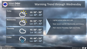
The storm system has moved east and Tuesday is expected to be mild.
Clouds are expected to move out throughout the day with a high reaching 53 degrees. Lows are expected to drop to 43 degrees overnight.
Bowers said temperatures won’t be quiet as warm as they were Monday. He adds that winds will still be gusty, but not nearly to the level that they were yesterday.


