
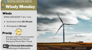
STATEWIDE–Storms and high wind gusts will be moving through Indiana today.
Most of the state will be under a wind advisory from 7 am until 7 pm this evening.
“A pretty significant storm system is coming out of the Plains. It’s moving into Indiana. The good news is it will pass quickly, so once we get through today, it will be calmer for the next day or so,” said Randy Bowers, meteorologist with the National Weather Service in Indianapolis.
Bowers projects that wind gusts could reach around 50 mph at times.
“By the time we get to mid-morning and late morning we’ll notice a pretty significant increase in winds. They’ll continue through the afternoon and that’s when they’ll peak. They’ll continue in the evening, but then they’ll settle down late tonight,” said Bowers.
Thunderstorms will mix in with the winds.


“Those could be just intense enough to where they could enhance the winds locally and that’s what we’re concerned about,” said Bowers.
There is a “slight risk” for severe weather in much of the state. That means that scattered severe storms are possible but typically are short-lived and not widespread.
Temperatures warm up later in the week. Highs will reach into the upper 60s with mostly sunny skies on Wednesday. They’ll cool back down late in the week, but they’ll still be in the 40s, says Bowers.


