
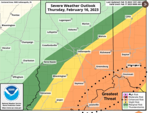
STATEWIDE–Damaging winds, small hail, and frequent lightning are just a few of the threats the National Weather Service (NWS) wants you to be aware of for Thursday across Indiana.
The NWS has put southeastern portions of Indiana are under an enhanced risk for severe weather. That means numerous severe storms are possible and some of them can be intense.
“It will start initially in the morning with rain and rumbles of thunder, but by mid-morning and early afternoon, that’s when we’re most concerned about severe weather. Damaging winds are the primary threats. The potential is definitely there for a tornado, especially near the Ohio River,” said Andrew White, meteorologist with the National Weather Service in Indianapolis.
White says the storms will move quickly.
“With those, there could be gusts 60-65 mph at times,” said White.
He believes the storms will be wrapped up by the evening commute Thursday.
“Then we will get into much colder weather for Friday and early into the weekend. Low temperatures will be in the 20s with highs in the 30s,” said White.


