
STATEWIDE–The National Weather Service is urging you to be ready to deal with snow and frigid temperatures later this week.
“We’re most confident in the extreme cold. The situation with the wind and the magnitude of the cold air moving in has us most concerned. The peak of that concern with snow will be once we get from Thursday night into Friday. That’s where we think the air will be the coldest,” said Randy Bowers, meteorologist with the National Weather Service in Indianapolis.
By Friday, Bowers believes most places will have high temperatures in the single digits. That will increase the risk for frostbite. That is a skin injury that occurs when a person is exposed to extremely low temperatures, causing the freezing of the skin or other tissues.
“It doesn’t take long to get into a bad situation with that. If you’re not protected and you’re outside, within a matter of minutes, you can get into a frostbite situation. That can happen so easily given the magnitude of the cold,” said Bowers.
He also urges you to let your faucets drip and keep your heat on. Plus, have an emergency kit in your car that includes water, snacks, first-aid kit, blankets, flashlight, extra batteries, portable cell phone charger, and emergency flares.
“There will be a lot of people traveling for Christmas, so that’s a concern. On top of that, we’ll probably have slick roads too,” said Bowers.
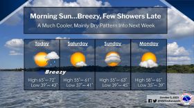
At this point, the NWS isn’t sure about snowfall totals, but they estimate that northern Indiana will likely get the most snow with lesser amounts further south.
“Rain chances are also pretty decent Thursday, but when the cold air moves in Thursday, that’s when it looks like will have a rapid transition to all snow,” said Bowers.


