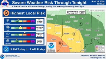
INDIANAPOLIS–There is a severe weather threat for the entire state of Indiana today.
The National Weather Service says the northwest tip of Indiana is under an “enhanced risk” for severe weather. Areas south of that are in a “slight risk” and the rest of the state is under a “marginal risk.”
A marginal risk for severe weather means that isolated severe thunderstorms are possible but are limited in coverage, intensity, or duration. A slight risk for severe weather means scattered severe storms are possible but typically short-lived and not widespread. An enhanced risk for severe weather means numerous severe storms are possible and are more persistent and widespread with a few instances of very intense storms.
“It looks like it will reach Lafayette and areas north of there between 7 and 8 pm. It will then move slowly to the southeast impacting parts of the Indy metro between 9 and 11 pm. Then it will reach portions of southern Indiana later in the night,” said Aaron Updike, meteorologist with the National Weather Service in Indianapolis.
Updike says the primary threat to look out for is damaging winds.
“There will be a small threat of hail and a small threat of isolated flooding, which could be worse depending on where you live,” said Updike.
Updike believes many places in northern Indiana could get between an inch and a half of rain.
“Northwest portions could get more than an inch and a half. There might be higher amounts depending on where those thunderstorms track, but generally about an inch is right,” said Updike.
Showers could linger on Tuesday, but Updike believes the rain should be gone by Tuesday afternoon at the latest.
“Then the rest of the week looks fairly dry. We’ll see seasonal temperatures in the low to mid-80s, but it should be dry through the weekend,” said Updike.
LISTEN: Full interview with Aaron Updike


