STATEWIDE–Rain will continue to fall across most of the state throughout Tuesday and a good portion of Wednesday.
“We’re certainly talking about rain that can reduce visibility while you’re driving and make it difficult for you. It could result in flooding in some low-lying areas. You’ll want to reduce your speeds,” said Jason Puma, meteorologist with the National Weather Service in Indianapolis.
Puma expects most locations in the majority of the state to get anywhere to get between one and two inches of rain by the end of Wednesday.
“We can’t rule out an isolated severe storm on Wednesday afternoon or morning. The main threat might be damaging winds, but we’re not expecting a whole lot of severe weather. Then we’ll have those rain chances persisting on Thursday and into Friday before we get into Saturday. After Saturday, we’ll look for dry weather,” said Puma.
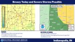
From 8 am Tuesday through 8 am Wednesday, the National Weather Service has listed much of central Indiana under a marginal risk for severe weather. The far southern portion of the state is under a slight risk.
From 8 am Wednesday through 8 am Thursday, the National Weather Service has listed the entire western part of the state and most of central Indiana under a marginal risk for severe weather.
A marginal risk for severe weather means that isolated severe thunderstorms are possible but are limited in coverage, intensity, or duration.
A slight risk for severe weather means that scattered severe storms are possible but typically are short-lived and not widespread.
LISTEN: Full Interview with Jason Puma